OWNERSHIP
Option to 80%
Option to 80%
Antinomy, Gold and Silver
Racha Region of Georgia
The Project has a 30-year mining and exploration licence and covers 1,779 hectares in the northern part of the Racha region; approximately 170 km from Kutaisi (second biggest city in Georgia), which has rail infrastructure links to the two western ports of Georgia.
Extensive historical exploration by the Soviet departments has been undertaken, with well over 27 km of exploration drives (adits) developed, over 20,000 channel (face samples) samples, extensive mapping and preliminary metallurgical testing, between 1929 – 1979. More recent exploration has undertaken channel sampling of the adits walls, additional metallurgical testwork, geophysical surveys and LiDAR surveys of the main adits and topography.
The Project contain multiple veins of narrow antinomy rich mineralisation with an extensive halo of gold mineralised country rock. No drilling has been undertaken at the project and as such no JORC compliant resources or estimates have been completed.

Figure 1 – Location of the Zopkhito project, Georgia; and associated infrastructure (Roads=White, Rail= Black, Port=Red)
Geologically the regional project area belongs to the Great Caucasus Thrust Belt, along which the Lower Jurassic thick slate sequence is seated on the Palaeozoic granite. It is a part of the Tethyan Belt spreading from the Carpathians in the west to northern Iran and further on to the East.
The Zopkhito deposit is an orogenic Sb-Au deposit linked to the Mesozoic/Cenozoic genesis of the Caucasus Mountains. The deposit sits within the southern slope zone of the Greater Caucasus range, which is the footwall of the main range zone. The host rock geology comprises mainly siliciclastic comprising Jurassic basal conglomerates overlain by sandstones, polymictic breccias, sandy and carbonaceous shales as well as slates.
The Sb-Au mineralisation of the Zopkhito deposit is associated with narrow quartz-stibnite veins hosted by carbonaceous shales and slates. Veining is associated with a wider hydrothermally alteration zone surrounding the Sb-Au-rich veins. Alteration includes silicification and sulphidisation of the shales and slates with increasing proportions of pyrite and/or arsenopyrite. The alteration halo shows elevated concentrations of minerals and metals of economic interest, particularly microscopic Au hosted in/by arsenopyrite. The halo extends metres into the hanging- and footwall of the veins. In addition, there is significant development of a quartz-stibnite stockwork/stringer zone in areas adjacent to the principal veins identified.
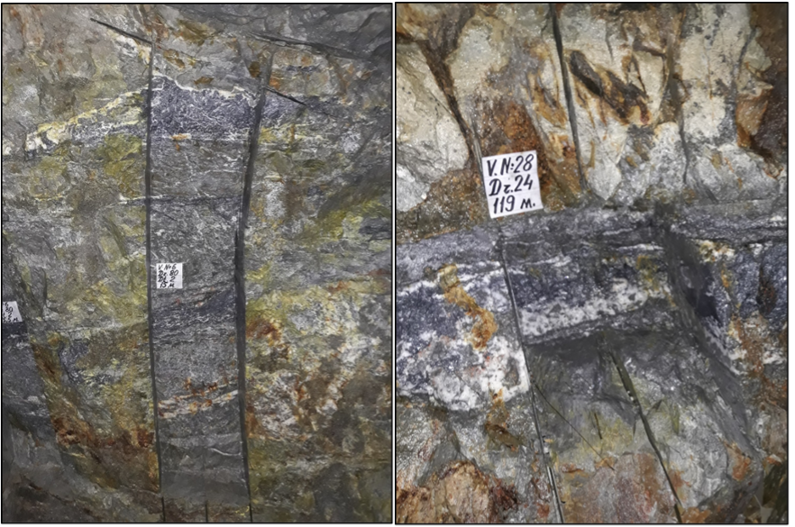
Photographs of 2019 channel sampling. Left: Sample 80-20-01-15 (Sample length is 0.98m with 10.4% Sb), Right: Sample 24-01-119 (Sample length 0.13m with 8.34% Sb).
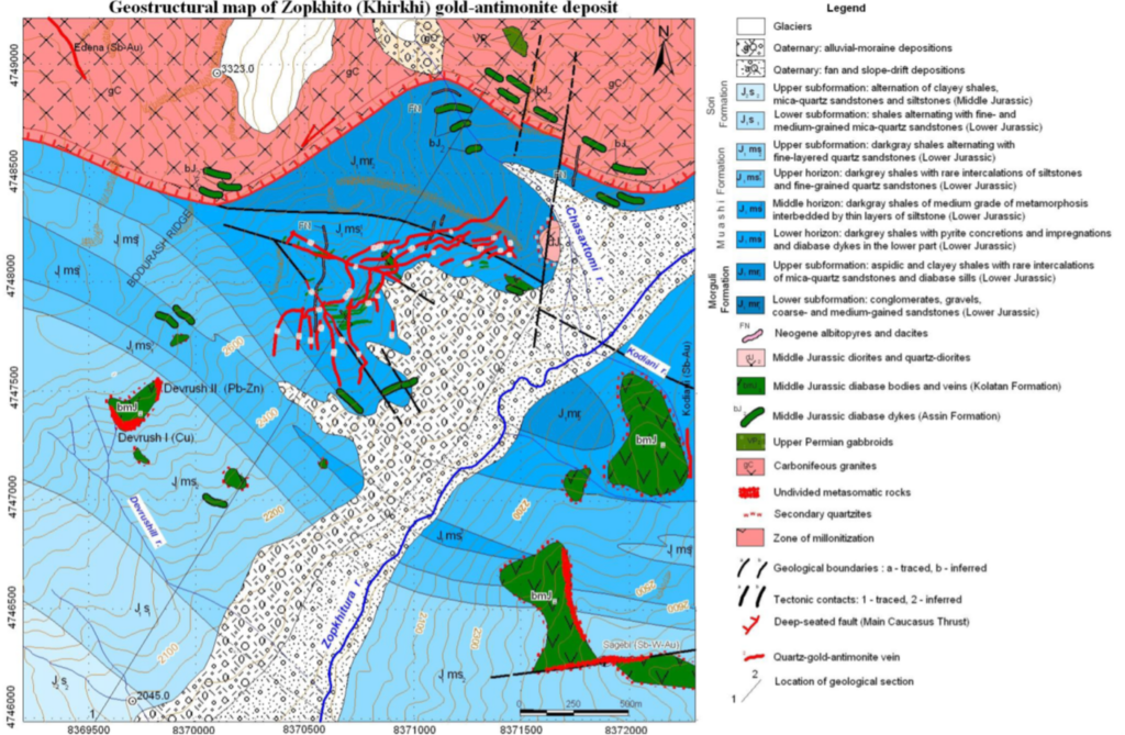
Figure 2 Geo-structural map of the Zopkhito Sb-Au deposit.
Foreign estimates completed by Eastern Mediterranean Resources Public Ltd (“EMED”) in 2007 and 2008 report the resources to contain over 26,000 tonnes of antimony and 815,000 ounces of gold. Tabulated details of the resources are shown below. The estimates were based on the EMED assays and previous Soviet exploration works. Key details are summarised in ASX announcement dated 9th December 2024.
EMED used the State Commission for Reserves; Gosudarstvennaya Komissia po Zapasam (“GKZ”) guidelines and methodology for the resource estimation. It is understood that these resources were not registered with the State, but were disclosed publicly on AIM. It is understood that EMED relinquished the licence in 2008 to focus on the Riotinto mine in Spain.
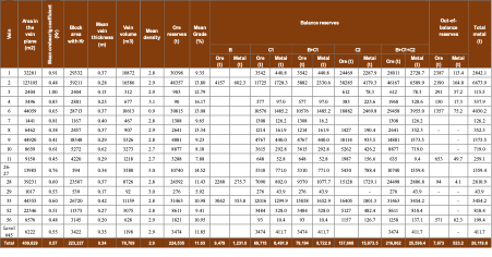
Table 1 EMED 2008 – Zopkhito Sb Resource (Russian GKZ System) (Note that references to ‘reserves’ here are not ‘Reserves’ under the JORC Code 2012, but more akin to ‘Mineral Resources’
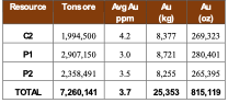
Table 2 EMED 2007 – Zopkhito Au Resource (Russian GKZ system)
The foreign estimate of mineralisation in respect to the Zopkhito Antimony and Gold project reported here are “foreign estimates” for the purpose of the ASX Listing Rules. The foreign estimate is not reported in accordance with the JORC Code 2012
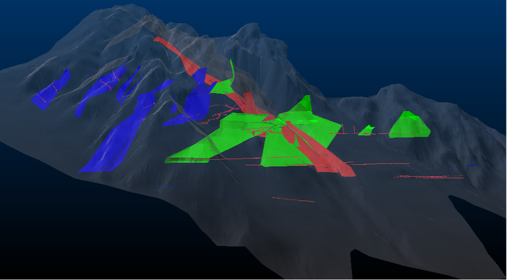
Image showing 3D wireframe modelling of 13 veins (blue, salmon and green); historical adits sample (red and blue dots) locations, within DTM topography (transparent grey) looking north.
Two main types of gold mineralisation zones have been distinguished:
Initial metallurgical test work undertaken in 2012 reported Sb rougher recovery greater than 90% from a high grade Au and Sb sample. More advanced floatation processing testwork followed in 2018. A 800kg sample was tested with a head grade of 2.2% Sb, 1.7% As and 2.7g/t Au. The tests achieved a single selective stibnite float route with one cleaning stage, to produce a high grade Sb-product, with low As.
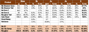
The outcomes showed that at a grind size of 80 per cent passing 75μm, it was possible to produce the Sb product grading 56% Sb with As content of 1.8% As.
It was concluded that additional cleaning stages in the Sb product could be added to improve the quality of the final product, and that finer grinding may assist with higher gold recoveries.
Additional optimisation will be undertaken to maximise return. Multistage cleaning to further reduce the As content on the final Sb product and maximising the Au recoveries in the As floating step could improve the results. Other downstream processing and purification tests will be examined.
Exploration of the Zopkhito Sb-Au deposit commenced in 1929 and continued until 1979 under the management of the Soviet Department of Metallurgy. Between 1929 and 1932, work started on the development of on-vein horizontal exploration adits. The underground workings were directed by stibnite mineralisation outcropping on surface. Exploration drives at Zopkhito are typically 2-3 m high and 1.5 m wide. Up to 1956, channel samples were taken from the vein face at 1 m intervals for Sb, with limited Au and Ag assays at 10 m intervals from selected drives.
In 1957, a report was submitted to the GKZ by the exploration institute describing work done in detail. Pleasingly, this report includes similar outcomes for mineralisation as reported by EMED with respect to the antimony deposit.
From 1966 until 1978, further drive development extended the orebody. In total 27,328 m of exploration drives were developed up until 1978 with 20,228 samples taken. During this work extended channel sampling discovered that Au-bearing mineralisation occurred in the broader alteration zone outside the main quartz vein which hosted the Sb mineralisation (with gold) which had not been sampled.
Channel sampling during these exploration phases is believed to have comprised 5 to 10cm wide channels, with length dependant on the vein morphology, with sample intervals typically 1m at the advancing adit drive face.
Further exploration and data records showed concentrations of Au to be higher than previous exploration works had demonstrated.
After the collapse of the Soviet Union in 1989, the project lay dormant until the late 1990s. Exploration work continued between 1998 – 2000 by a small exploration company. The work comprised of collecting 71 samples. As part of this work, ACA Howe International also collected 33 samples for multi-element assays, from which it was concluded that existing GKZ maps and plans are reliable and that elevated Au grades occur also outside the Sb- Au-quartz veins.
In 2005 EMED acquired the rights to the Zopkhito deposit and carried out an extensive re-sampling (> 800 samples) program and remodelled the vein systems, confirming the reliability of the 1957 Soviet report. In 2007 and 2008 EMED disclosed resource estimates for the Zopkhito deposit based on the newly acquired data and GKZ data. The antimony resource was consistent with the 1957 GKZ report, while the gold resource was increased dramatically to account for the alteration zone gold mineralisation which was not part of the GKZ report in 1957. From 1995, exploration programs were completed by BHP, Astro Mining NL, and All Star Resources Plc. A summary of this work is detailed below.
In 2012, a 30 year exploration and mining license was granted to JSC Caucasus Minerals (“JSCCM”), the current project vendor. JSCCM carried out adit face re-sampling programmes in 2014 and again in 2019. The JSCCM resampling work focused on three main drives/adits which were open and safely accessible, namely adit 80 (Vein 6), 24 (vein 28) and 117 (vein 6). The 2014 sampling programme collected 6296 samples from 11 veins for Au and 13 veins for Sb. This programme also included sampling of immediate foot and hanging walls of the veins. Approximately 2000 samples were collected from the main mineralised Sb veins and assayed. The sampling was spaced at intervals approximating the location of historical GKZ channel samples to help support the development of a JORC mineral resource estimate, however the original samples were taken from the advancing face of the adit drive and perpendicular to the vein. It is thought that although samples are typically close spatially, they are reasonably grade variable, a typical characteristic of this style of mineralisation, thus are not suitable for Mineral Resource estimation under JORC 2012 without further work.
Sampling in 2019 was undertaken to further understand and compare the variation of Soviet and 2014 samples and help provide a pathway for future sampling to contribute to Mineral Resource estimation under JORC 2012. Around 90 samples were taken. Of note the following samples returned significant Sb results (which are reported herein under JORC 2012).
JSCCM also completed bulk sampling for metallurgical processing sighter testing and undertook a successful IP/ AMT geophysical survey programme in 2017/2018. JSCCM also completed a drone LiDAR survey over the topography at site and a point cloud LiDAR survey of the various principal adits and drives to assist with accuracy on the geochemical sampling and allow accurate modelling of the veins. Various mineralogical studies have been undertaken with the most recently completed in 2018.
The Soviet sample data from the various reports were freshly transcribed and remodelled along the new data to support the 3D model. The validation showed only minor inaccuracies with the historical and current locations. No drilling has been undertaken at the project to the Company’s knowledge.
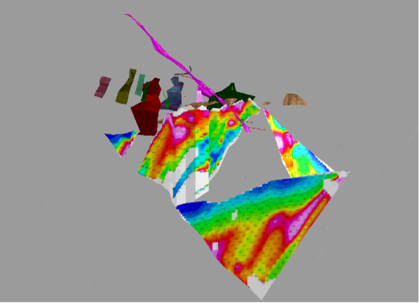
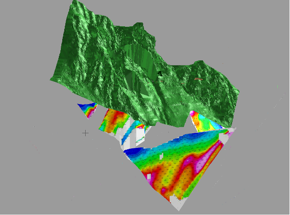
Image showing 3D wireframe modelling of with historical adits sample and location of IP geophysical survey showing chargeability; solid topography shown on bottom image. Images looking north – north east